
Hickory Regional Airport

Keep an eye
on the wind.

One windsock. An entire atmosphere to defy.
Live from the front lines at KHKY.

Windsock cam / 01
Connecting

Finding the windsock

Connecting to the camera…

Watch the wind

Getting timelapses ready…

Camera orientation

Looking ENE≈ 078° true / 086° magnetic

← Roughly northRoughly south →

Top of compass = away from camera.

The METAR sock

Waiting for METAR…

Elevated diagram view; METAR-based weather and motion are illustrative.

Runway 24 to the left. Runway 06 to the right.

Camera location

The field report

Weather at KHKY

Loading official weather…

Official METAR

Waiting for observation

HKY ASOS simulation / 118.325

A current observation is needed for the simulated announcement.

Simulated announcement & source

The simulated announcement will appear here when weather is available.

Simulated audio reconstructed from the METAR. This is not the live HKY ASOS broadcast. The radio can carry a newer observation. Density altitude is estimated.

Observation details & raw METARRemarks · original report
The latest observation is not available yet.

No successful source check yet.

Terminal forecast / TAF Waiting for forecast

Original TAF & source check
The latest forecast is not available yet.

No successful source check yet.

NOAA / NWS Aviation Weather Center Source checked every 5 minutes · display times Eastern · raw reports UTC

The night shift

Sun & night flying.

KHKY · Hickory, North Carolina
Airport time · Eastern

Calculating today’s solar times…

Sunrise

—

Civil dawn —

Sunset

—

Civil dusk —

Tonight’s windows

Noon to noon · Eastern time

Position lights—Sunset → sunrise
Log night time—Civil dusk → civil dawn
Night currency window—1 hr after sunset → 1 hr before sunrise
Runway 06 glare—055° true · calculating…
Runway 24 glare—235° true · calculating…
Landing sun glareDeeper color = closer low-sun alignment.Stripes = clouds or obscuration reported.

Solar geometry only until a current METAR is available.

Calculating the current night windows…

Glare colors estimate low-sun alignment, not measured glare intensity. Cloud position and cockpit conditions can change actual glare.

Timing rules & calculation notes

The first three bars show FAA timing windows; their labels round inward to the minute. Glare rows show estimated low sun ahead, sampled each minute. Times are Eastern at KHKY; hover a time for UTC. The graph runs from noon on the selected date to noon the next day. Returns to now after one minute of inactivity.

Glare bands use sun elevation up to 20° and azimuth within 25° of the true landing heading. These are display estimates, not measured glare intensity. Terrain, cloud position, windscreen, aircraft attitude and reflections can change actual glare. FAA sunlight research ↗

Position lights: sunset to sunrise. §91.209 ↗

Log night time: the end of evening civil twilight to the beginning of morning civil twilight. §1.1 ↗

Night currency: takeoffs and full-stop landings from one hour after sunset to one hour before sunrise can count toward §61.57(b) currency. Three takeoffs and three full-stop landings in the preceding 90 days, as sole manipulator, in the same category and class (and type, if required); see the rule for exceptions. The timing window alone does not establish currency. §61.57(b) ↗

Calculated estimates for KHKY and a standard horizon; verify published times with the U.S. Naval Observatory ↗. Terrain and weather can change when the sun is visible.

The view in context

Camera to windsock.
View full-size diagram
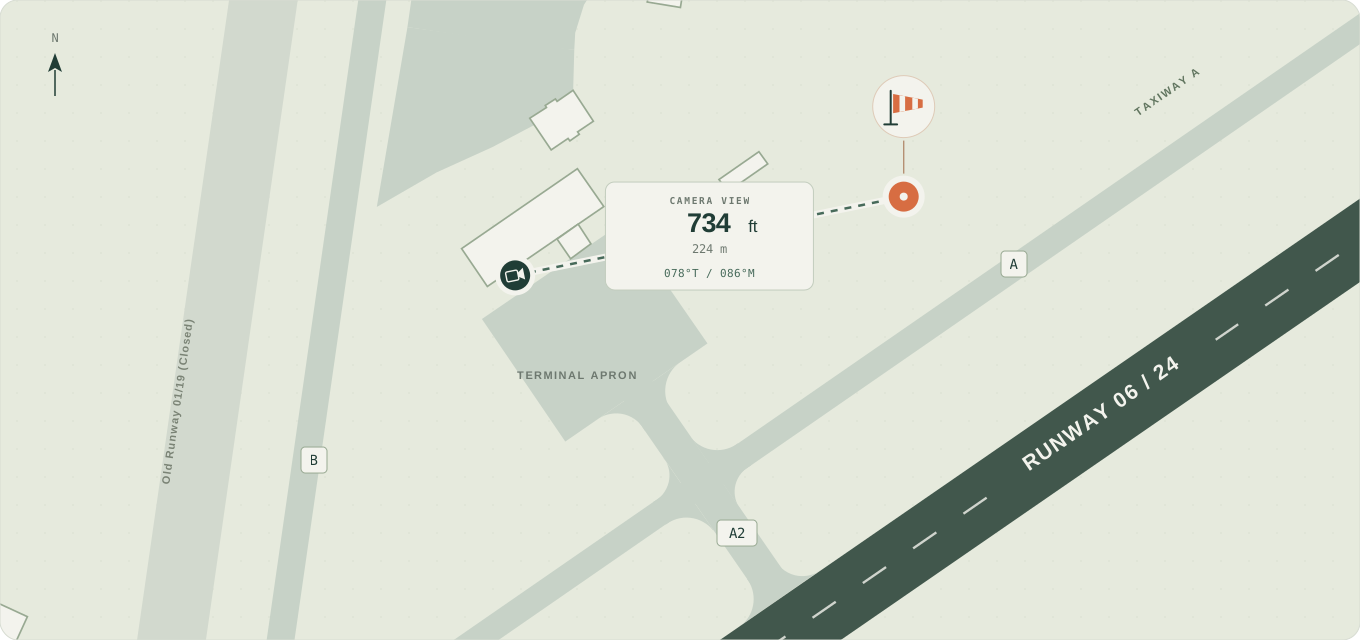
Overhead view of KHKY: the camera is beside the terminal apron, with the windsock to its east-northeast. Taxiway A and connector A2 lie between the apron and Runway 06/24; Old Runway 01/19 (closed) and Taxiway B are to the west.
Camera → sock734 ft224 m across the apron
Camera bearing078° true086° magnetic · ENE

A little wind trick If the sock’s tail points directly away from the camera, the wind is coming from about 258° true (266° magnetic).

Map & bearing sources

Layout based on the FAA airport diagram (October 2026). Camera and windsock positions are approximate. Magnetic reference: NOAA WMM2025 , October 2026.

The origin story

But, why?

In a world where the skies rage with unrelenting fury, where howling tempests descend upon unsuspecting aviators, and the very winds themselves conspire to challenge mankind's dominion over the heavens, there stands a lone, steadfast sentinel. Unarmed. Unafraid. Unwavering. A humble warrior of fabric and steel, standing vigil near the runway at Hickory Regional Airport. Through thunderous storms and the darkest nights, through blistering heat and bitter cold, it rises to fulfill its sacred duty: to face the invisible forces of nature and reveal their secrets to those brave enough to take flight. Neither glory nor gratitude does it seek. Only the solemn honor of pointing faithfully downwind, so that others may soar safely above it...

...Okay, not really. It's a windsock. We put a camera on it.

Because it's cool. Because it's useful. And because sometimes you just want to see which way the wind is blowing without deciphering a METAR.

But perhaps the better question is... why not?

sock.cam / a Bearonautics picture

Establishing contact

KHKY / 35.74° N · 81.39° W

The field dispatch

Waiting for METAR…

Awaiting the official report.

The vigil continues.

A Bearonautics presentation00:00 / 00:49

An opening-credit sequence introducing the windsock, weather, tactical reconstruction, and airport, followed by the live KHKY windsock camera with reported METAR wind and an illustrative windsock. Sound can be muted and the opening can be skipped. Escape or Exit returns to the main page.